| Early water mills were mostly used for grinding corn, then from the 13th century for a variety of other purposes, especially for ‘fulling’ or thickening woollen cloth.
There was a dramatic growth in the number of mills in the late 18th and early 19th century. A growing population and the rise of the cotton industry meant an increased demand for water power. The new mills were built for cotton spinning and later adapted for other textile processes.
The map shows how many working water mills there were in the Upper Calder Valley. Some continued in operation until the 20th century.
Most of the mills were built on tributaries of the River Calder. The most important factor in the siting of mills was the availability of water with a good fall.
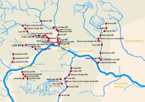 |
Water Powered Mills in the Upper Calder Valley (interactive)
This map shows the number of water powered mills in the Upper Calder Valley in the early 1800s and the watershed of the River Calder which supplied them. |
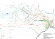 |
Colden Valley Map (interactive)
This historical characterisation map shows the mill sites and associated features of the Colden Valley, a tributary of the River Calder. |
 |
Maps and Plans |
|